When AI met geospatial
When two powerful technologies join forces it’s always interesting to see what will happen. The government is using AI and geospatial to understand land use in the UK, having piloted a new tool that takes satellite data and communicates sophisticated analytics through an interactive LLM that can support local land use planners in their decision making.
To explore the issue, we met with Professor Daniel Arribas-Bel and Emma Warneford to discuss the new tool and what it could mean for the future of AI and geospatial in the UK. Professor Arribas-Bel is the Deputy Director of Urban Analytics at the Turing Institute, leading the technical development of the tool. Emma Warneford is a senior land use planner at Newcastle City Council and was one of the key local stakeholders and recipients of the tool.
 Professor Arribas-Bel began the interview by saying, "The Turing Institute is internationally recognised for its technical talent, but it's challenge is understanding how to deploy it. Where can we apply this technology in a way that genuinely helps everyday people? That is a global challenge and a question no one really has a clear answer for yet."
With local councils facing tight budgets, supporting their data management can often be an afterthought. This is compounded by difficulties in the labour market. Whilst domestic talent in the UK is relatively strong when it comes to data analytics, what we don’t have and can’t afford, is a geospatial-trained data scientist for every local council in the UK. In the face of this problem, Professor Arribas-Bel’s team asked themselves, "How can we stretch the value of the talent at the Turing Institute?" The hypothesis being tested for this question is Large Language Models (LLMs).
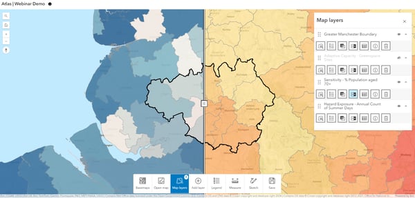
LLMs undergo training on vast datasets, empowering them to comprehend and create natural language. The experiment was as follows, the Turing Institute, in collaboration with the Geospatial Commission integrated an LLM-based interface in the form of a chatbot or as the Professor liked to call it, "a virtual intern" into a land use analytics tool. This user-centric experience allows Newcastle City Council to take their priorities of Air Quality, House Prices, Job accessibility and Green Space accessibility and experiment with how their prospective plans will affect these priorities and outline the implications and opportunities in plain English for local land use decision makers.
 One of these decision makers is Emma, who has worked for Newcastle City Council for almost thirty years. She notes that the key advantages of this tool was its potential to promote transparency. She told us, "the new tool has changed the way we think about transparency. Most of the time, our data is siloed into lots of separate paper-based reports. Moving forward, we’re thinking about having a visual digital map that citizens can engage with on our website and that’s underpinned by geospatial data." Though Newcastle City Council is yet to implement the tool, she notes that the tool has already influenced, "how we operate, assess sites and our move away from a lot of documents and towards a database approach".
Emma continues, "The technology opens the door for datasets that are transparent and easy to communicate through public consultation. The potential to use this AI tool when datasets change is potentially very valuable. Currently, if a new set of population projections or household projections comes out from the central government, we'd have to go through lots of reports to update the data. In future, if we use AI, we'd be able to then just literally put the datasets in the tool and lots of maps would automatically update." Saving on manual processes may be a modest use for AI, but that doesn’t make it any less helpful. Emma makes that clear, especially when it comes to serving civic transparency by allowing the public to visually engage with their land and redirecting local council’s time away from routine activities and towards better service delivery.
 A cornerstone of this transparency is exhibiting the trade-offs inherent in land use decisions. Jean Innes, CEO of the Turing Institute commented in a press release on the tool, "The way we use land will be more crucial than ever in the years ahead as the UK targets economic growth and prosperity whilst ensuring we protect the environment and adapt to climate change". The trade off between economic development and environmental protection is salient one, both in the UK and globally. When asking Professor Arribas-Bel how the prototype contributed to this balance, he responded, "making explicit the inherent trade-offs in land use planning was a focal point of the Geospatial Commission’s National Land Use Programme". He continued, ‘no singular indicator can be optimised alone, you always have to look at it in the context of other indicators. By varying the different degrees of the indicators according to the type of land use being analysed, for instance, compact residential development, you can simulate predictive scenarios.’ Giving the example of Victorian England, he described how the land use represented an almost extreme optimisation of industrial development causing extreme pollution and environmental damage. This tool exposes these trade offs before site selection and investment occurs, empowering the local decision maker.
Emma further added, ‘To be able to see for yourself what the limitations are in a structured way is very powerful. After we decided on publicly accessible datasets for the tool, we saw its utility in helping us with our site selection such as in measuring site constraints and assumptions, and then layer those up using the tool. We've got to make sure people understand the ramifications of their decisions around land choices."
Looking to the future, this story tells us something far greater than land use alone. It gives us a glimpse into the potential for LLMs to be used as a tool to fill the technical skills gap in data analytics and to aid local councils in creating a transparent and intuitive data management system, which in this case was through visual maps.
Professor Arribas-Bel’s final thoughts were, "It’s rare that you will find someone who is both a technical expert and an operational delivery expert. This tool bridges this gap and can be used as a template for their unique challenges far beyond land use planning. This is a great use case for people in government who want to utilise sophisticated data analysis but also want it to be accessible for non-technical users."


